
The description of Polaris Navigation GPS
Turn your phone into a powerful GPS navigation system with Polaris Navigation GPS, the world's #1 all-purpose GPS, and dare to go where there are no roads. Imagine… What would it be like to navigate any waterway or hike any wilderness or city using only your phone's GPS location abilities and a view of the sky? What it would be like to create navigation destinations without the need of an internet connection and find them using only an arrow or offline maps.
That is just a glimpse of the navigational power you will hold in your hands when you install Polaris Navigation GPS.
Used mostly as a hiking, off road, nautical and trail GPS app, Polaris is an excellent backup or replacement for your Garmin or other handheld GPS unit and will keep you oriented wherever your outdoor adventures take you!
Typical usage: Makes an excellent hiking app for exploring the backcountry, recording and viewing tracks, boating, fishing, hunting, geocaching, camping, sailing, mountain biking, backpacking.
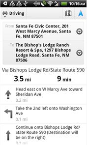
Road navigation and verbal street directions are provided through a digital pipeline connecting the power of Polaris to the Google Maps app on your device.
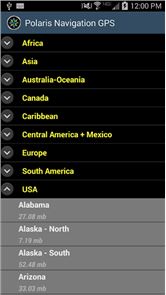
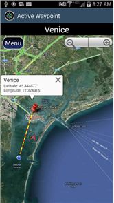
Used by land-sea search and rescue, military personnel and millions of others worldwide, Polaris offers lots of map choices. When you install Polaris, you get free access to our map library with hundreds of downloadable offline maps and most of the online maps in Polaris are cached for offline use. You even have the flexibility to build your own maps from a variety of sources using the Mobile Atlas Creator map tool.
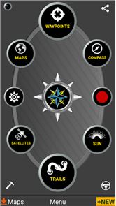
This powerful navigation system also includes:
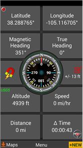
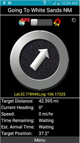
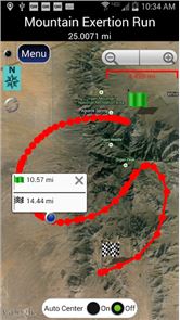
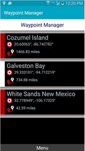
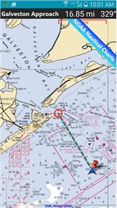
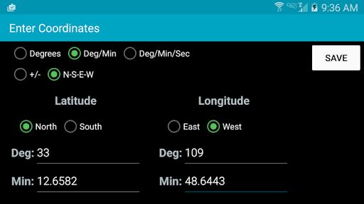
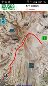
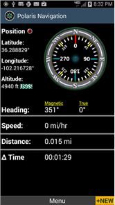
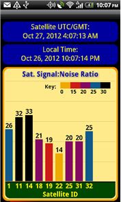
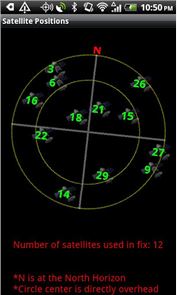
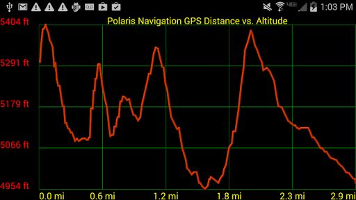
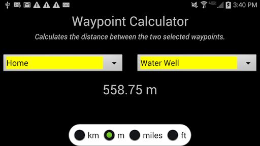
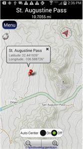
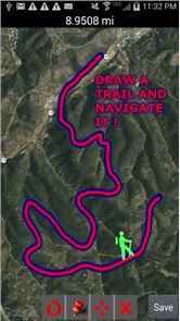
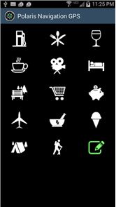
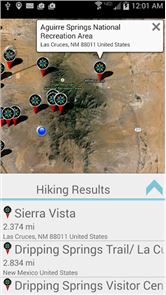
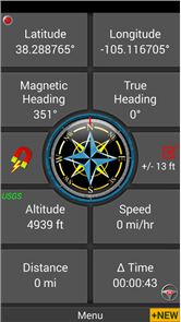
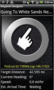
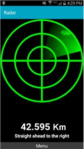
★ Panels for all standard GPS parameters★ Odometers, altimeters, speedometers, chronometers★ No subscription fees. Does not require any special accounts★ Tap anywhere on a recorded track to get split distances to track endpoints★ Robust waypoint and trail management systems★ Plot or draw a trail and navigate it★ Google Maps, OpenStreetMap-Mapnik, Topographic Maps, Cycle Route and Hiking Maps, Vector Maps, USGS Topo Maps, NOAA Marine Charts, World Aviation Operations Charts, Canada Toporama.★ GPS Tools and Satellite Diagnostics- satellite count, location, signal strength and more.★ Waypoint navigation system which includes a dynamic waypoint-finding compass that will help you navigate to any saved waypoint with certainty while reporting estimated time of arrival, distance to target and other statistics. Just follow the arrow!★ Trail navigation system★ Trail altitude profiles★ Location Sharing – Share your location by Email or SMS. Receiver gets a map with your position.★ Coordinate formats: latitude/longitude as degrees, deg:min, deg:min:sec, and UTM (Universal Transverse Mercator).★ Military Coordinate Finder – Military Grid Coordinate Reference System (MGRS).★ Hiking Trails – Most of the maps show hiking paths courtesy of the Openstreetmap project. We are always amazed to find that even some of the most obscure hiking routes in our state are available.★ Marine navigation- NOAA Nautical Charts and Openseamap for selected areas.★ Select source for altitude reporting: Satellites, United States Geologic Survey or map your location to the results of NASA's Space Shuttle Radar Topography Mission★ Data protection- Your data is backed up regularly meaning you will not lose your progress should your battery need replacement while en route to your destination.★ Waypoint photography.
★ CREATE MBTILES BASED MAPS FOR OFFLINE NAVIGATION. INSTRUCTION VIDEO AT: http://www.youtube.com/watch?v=Y3RtFvPna1A
★Map Search and Coordinate Conversion capabilities with the free MapIt! plug-in
★ Improved compatibility for maritime navigation with addition of nautical and NOAA marine charts.
🔍✅ COMPARE POLARIS NAVIGATION AND GPS WAYPOINTS NAVIGATOR AT:🔍✅ http://discipleskies.com/Polaris_Navigation_GPS.html
★ Additional Screenshots at: http://www.gps4free.com ★
How to play Polaris Navigation GPS on PC
Download and Install Nox App Player Android Emulator. Click here to download: Download(FREE)
Run Nox App Player Android Emulator and login Google Play Store
Open Google Play Store and search Polaris Navigation GPS Download
Install Polaris Navigation GPS and start it
Well done! Now you can play Polaris Navigation GPS on PC, just like Polaris Navigation GPS for PC version.